
EQUIPMENT & GIFT SHOP
We stock a small selection of items that we feel complement the events we run. These will be discounted if you book on one of our events.
Gift vouchers can be used on any of our guided walks, hill skills courses or the items below.
Please note: these items cannot be bought at the same time as purchasing an event (guided walks, courses, etc), they will appear in a separate basket.
Give an experience to remember, give a gift card
HIKING EQUIPMENT
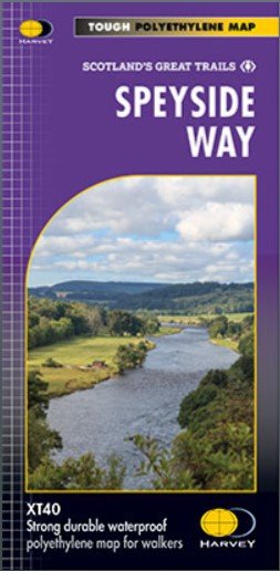
Entire route on one map
One of Scotland’s Great Trails.
The Speyside Way is 137km (85 miles) long and runs from Newtonmore to Buckie, via Kincraig, Aviemore, Nethybridge, Grantown and Fochabers, with a 24km (16 miles) spur to Tomintoul.
This map shows the route in its entirety, including the recent extension from Kincraig to Newtonmore, on one lightweight, double sided, folded map.
Tough, light, durable and 100% waterproof
Genuine original HARVEY mapping
Route clearly marked

Made from a high-tenacity ripstop nylon fabric, this 5L dry bag is both lightweight and durable. Siliconised coating on the outside of the fabric and PU coating on the inside, with fully taped seams will ensure your contents will stay perfectly dry.
The translucent bright colour will help you separate and identify your gear with ease. Simply roll the top over 3 times and close using the lightweight Kross buckle to keep all water out.

Made from a high-tenacity ripstop nylon fabric, this 2L dry bag is both lightweight and durable. Siliconised coating on the outside of the fabric and PU coating on the inside, with fully taped seams will ensure your contents will stay perfectly dry.
The translucent bright colour will help you separate and identify your gear with ease. Simply roll the top over 3 times and close using the lightweight Kross buckle to keep all water out.

Made from a high-tenacity ripstop nylon fabric, this 10L dry bag is both lightweight and durable. Siliconised coating on the outside of the fabric and PU coating on the inside, with fully taped seams will ensure your contents will stay perfectly dry.
The translucent bright colour will help you separate and identify your gear with ease. Simply roll the top over 3 times and close using the lightweight Kross buckle to keep all water out.

Recommended by the Duke of Edinburgh’s Award, the Trek first aid kit is the perfect size for many daily outdoor activities and is great for dealing with small accidents. The kit provides essential first aid items for treating cuts, grazes, blisters and other minor injuries.

Description
The Midge & Mosquito Head Net is made with our finest black mesh with 1001 holes per square inch. This head net will protect the head, face and neck from annoying flying insects when outdoors. Manufactured from tough, multi-filament polyester material and with a toggled draw cord around the rim, the head net weighs just forty grams. Use in areas with a high population of small and biting insects.

The Sherpa 60:70S is one of the most popular hiking rucksacks. The Sherpa rucksack is fully equipped with the Self Adjust Back system, durable components and clever features giving an edge when it comes to efficient load control and performance. The Sherpa 60:70S is an all-round rucksack recommended by The Duke of Edinburgh's Award because of its shaped adjustable harness, providing optimum fit and comfort alongside the AirMesh straps allowing air to flow, keeping the user cool. Ideal for multi-day treks and activity. The S stands for shorter back length and will provide a better fit for smaller users.

Perfect for youth group expeditions and beyond; Latitude punches well above its weight with a host of new features, using lighter fabrics, making it weigh 150g less with an even smaller pack size. The new trilateral construction allows for an independently floating layer of insulation which is not compressed by stitching, reducing cold spots and increasing the core temperature. Look out for Thermal Reverb, Thermal Embrace and its temperature regulating Helix Insulation among its many features designed to enhance its thermal capacity.
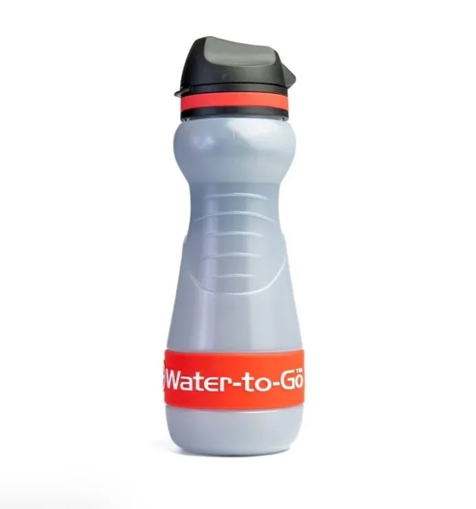
These bottles are a real weight saver. If you’ve planned your route you can factor in water stops easily enough. We’ve been using them on expeditions for years with no problems.
Perfect for lightweight travel.
The Water to Go Eco 55cl Filter Bottle in Blue is built with sustainable, next-generation eco materials. It replaces traditional plastics while delivering powerful filtration performance. Our included 3-in-1 filter removes up to 99.9999%* of harmful contaminants including bacteria, protozoa, viruses, chemicals, and heavy metals. Allowing you to drink safely from rivers, taps, streams, and more. This is something that most traditional water filters cannot handle. With a 200-litre filter lifespan, this bottle saves you money, reduces single-use plastic waste, and keeps you hydrated wherever adventure takes you.
Key Features:
The filter lasts for 200 Litres
100 days use at 2L/day
Replaces 400 single-use plastic water bottles
Weighs just 115 grams
BPA Free and Bonsucro accredited
Dishwasher safe
Refillable, reusable, recyclable
Ergonomically designed for a comfortable fit in your hand

Our recommended survival blanket, we demo these at all Hillgoers Hill Skills courses. The Blizzard Active Range Blanket provides shelter in an emergency situation. We prefer the blanket over the bag because it’s easier to put a casualty into a blanket but these have the same effect once you are wrapped up

The Spike Jet Zoom has unmatched needle speed and settling time and also features a large magnifying lens for more detailed map reading. The rotatable housing has 360° graduation markings, extended orienteering lines and a grip friendly surface. Furthermore the baseplate features a detachable scale slider at the tip making it our most comprehensive orienteering baseplate compass.
By changing the scales to fit your current needs you can more easily plan your race. You can even detach the scale slider entirely in order to achieve additional transparency for quicker map reading. With the Spike Jet Zoom, you get 3 separate scale sliders, that can also be flipped, giving you a total of 6 different scales to choose from – 1:40 k, 1:7.5 k, 1:10 k, 1:15 k, 1:3 k, 1:4 k. The stencil holes for start and control markings are great when you want to create your own orienteering race.
What stands out in the Spike Jet Zoom in comparison to its siblings Spike Jet and Spike Jet Classic is the built-in magnifying lens. It provides more flexibility and enables detailed map reading at a glance – perfect when every second matters.

Hillgoers highly recommends the Silva Expedition compass. This compass has everything you need as you progress through your navigation journey, from beginner to advanced with the added benefit of the slope card, which is ideal for winter.
Discounts offered for this product to those who attend a Hillgoers course. Contact us for more details.
The SILVA Expedition Series is for experienced users and professionals. The Expedition series has been a global leader when it comes to accuracy, precision and durability for many years. The SILVA Expedition Series comes with two completely new features: a Slope card and a Scale lanyard.

Hillgoers recommended compass is the Silva Expedition 4. This compass has everything you need as you progress through your navigation journey, from beginner to advanced.
Discounts offered for this product to those who attend a Hillgoers course. Contact us for more details.

The popular entry level compass SILVA Field has gone through a face-lift with updated colours and updated graphics. SILVA Field is an entry level compass designed to meet the demands of schools, youth groups and leisure outdoor navigators.
The SILVA Field has base plate map-measuring in mm and scales of 1:50,000 and 1:25,000 compatible with most maps. The compass features DryFlex™ rubber bezel for improved comfort and grip, and a detachable safety-release lanyard—a reliable companion in all situations!
Discounts offered for this product to those who attend a Hillgoers course. Contact us for more details.

Pacing beads and a 1m length of high visibility paracord!
This is a great replacement for the standard strings that come with some compasses. The cord can be tied to your compass and attached to your clothing, or bag via a clip or knot. The beads are metal sprung toggles, so recommended to keep these away from the compass end.
Please note, compass is not included…If you don’t know what pacing beads are used for, maybe think about a hill skills course!

Silva Begin Wrist Compass is the perfect entry-level compass for orienteering or trail running, perfect for school orienteering.
Small in size and designed for a child’s hand but it is fine for adults too. The wrist band safely attaches to the hand and you can focus on map and direction.
This is a robust wrist compass with rubber housing which makes it withstand even the toughest treatment and conditions. The needle is made from finest Swedish steel with high quality magnetic features.
Discounts offered for this product to those who attend a Hillgoers course. Contact us for more details.

A small curvy compass with thermometer and cardinal directions. With its small size and precise needle, this is the perfect compass to to bring along your hike.
Not for advanced navigation, but a great aid if you need to find the right direction or a backup for a more advanced compass. It fits right in your pocket and comes with a carabiner hook for attachment as well as a thermometer to keep you aware of your environment’s shiftings.
Discounts offered for this product to those who attend a Hillgoers course. Contact us for more details.

Silva M30 map case (300x300mm)
Waterproof
Withstands tough weather conditions
Lightweight
No need to carry unnecessary weight
Scale lanyard
2 scales, soft and bendable, easy to place directly on to your route on the map.
Fully transparent
Use the camera through plastic cover
Winter use
Flexible in temperatures down to -20ºC

Silva R-PET Dry Bags
The R-PET dry bags are made of lightweight, durable and 100% recycled material. They are made of recycled PET to make them as environmentally friendly as possible, but still rugged, waterproof and reliable – everything you can expect from a high-quality dry bag. Whether you are going camping, kayaking or sailing – these dry bags will protect your gear and they will keep our outdoors clean for future adventures.
No matter what weather conditions or surroundings that are facing you, your belongings will stay safe in the SILVA dry bags.
The R-PET dry bags are easy to stuff and close – roll the top edges at least three times, and close the buckle and your belongings are kept dry. The bags are made of lightweight, durable and 100% recycled fabric, suitable for any outdoor activity.

The Pocket 8X Binoculars from Silva
Pocket 8X is a lightweight, compact pair of binoculars perfect for hill walking, for wildlife spotting and getting close ups of route choices through glens or over hills when out walking. Silva’s binoculars are compact and sturdy enough for the great outdoors – natural travel companions that can be packed in your rucksack with the same straightforwardness as your compass.
The Silva Pocket binocular is a compact, reliable low-weight companion, always there when you need it. We bet there have been times when you wished you had brought your binoculars, on a trek, in the boat, the car or away at the cottage. With the super compact Silva Pocket you will have a friend that you can always bring along. Perfect as extra binoculars in the backpack or trouser pockets.
Dimensions: 90 x 65 x 40 mm
Optics: BAK-7, 21 mm lens, 8x magnification and 122m field of view
MAPS & BOOKS

Harvey Maps - Lochnagar, Glenshee and Mount Keen Ultramap®
We absolutely love Harvey’s Ultramap®. The small size and 1:40k scale is perfect for our needs and fits easily into the pocket. Being from Harvey Maps, it’s also tough and 100% waterproof
Covers a large area yet is handily compact. Pocket perfect!
Detailed map for runners and walkers of Lochnagar and the area south of Braemar. Covers Lochnagar itself, with Braemar at the north of the sheet and the Spittal of Glenshee at the south.
The Spittal of Glenmuick, and the popoular Loch Muick, lies to the east.
Scotland's most easterly Munro, Mount Keen, is included as an inset.
Includes 22 Munros, 5 Corbetts and 1 Graham.
Technical specification:
Scale: 1:40,000
Ratio: 2.5cm = 1km
Flat size: 870 x 304mm
Folded size: 73 x 152mm
Weight: 25gms
Area of mapping: 674sqkm
Double sided
Entire route on one map
One of Scotland’s Great Trails.
The Speyside Way is 137km (85 miles) long and runs from Newtonmore to Buckie, via Kincraig, Aviemore, Nethybridge, Grantown and Fochabers, with a 24km (16 miles) spur to Tomintoul.
This map shows the route in its entirety, including the recent extension from Kincraig to Newtonmore, on one lightweight, double sided, folded map.
Tough, light, durable and 100% waterproof
Genuine original HARVEY mapping
Route clearly marked

Map of Glen Coe on playing cards.
Cards join together to form a map!
Map area shown covers Glen Coe Village in the West and East to Glencoe Mountain ski centre.
The perfect gift!
Shows original HARVEY mapping
Glen Coe shown across 52 cards
Each card shows a unique piece of map
Standard pack contains 52 playing cards and 4 jokers
Box size: 92 x 66 x 19 (mm)

We absolutely love Harvey Maps products.
Detailed map for hillwalkers of the superb walking area south of Braemar at the popular scale of 1:25,000.
Covers Lochnagar itself, with Braemar at the north of the sheet and the Spittal of Glenshee at the south.
The Spittal of Glenmuick, and the popoular Loch Muick, lies to the east.
Scotland's most easterly Munro, Mount Keen, is included as an inset.
Includes 22 Munros, 5 Corbetts and 1 Graham.
Click here to view map coverage
Tough, light, durable and 100% waterproof
Genuine, original, HARVEY mapping
Opens directly to either side of the sheet
Easy to re-fold

Product Description
Map of West Highland Way on playing cards, the perfect gift!
Shows original HARVEY mapping
The whole of the West Highland Way shown across 52 cards
Each card shows a unique piece of map
Standard pack contains 52 playing cards and 3 jokers
Box size: 92 x 66 x 19 (mm)

Product Description
Entire route on one map
One of Scotland’s Great Trails.
The West Highland Way is 153km (95 miles) from Milngavie, near Glasgow to Fort William.
Tough, light, durable and 100% waterproof
Genuine original HARVEY mapping
Route clearly marked
Technical Specification:
Scale: 1:40,000
Ratio: 2.5cm = 1km
Flat size: 696 x 486mm
Folded size: 116 x 243mm
Weight: 35gms
Double sided
Format: strip map

THE EXCELLENT HARVEY MUNRO & CORBETT CHART!
This Munro map is a chart which shows and lists all Munros (mountains over 3000ft), Corbetts (over 2500ft), Grahams and Donalds (over 2000ft). A selection of other hills are named for information.
Size 880x1145mm.
Space for recording your date of ascent, Hillgoers can help you achieve them!

The Munros book provides a compendium of maps including coverage of every Munro (hill over 3000'). It will assist the planning of countless days of hillwalking. By its nature it is a picture of the upland topography of Scotland.
For the map lover, here is a feast of topographic delight. For the outdoor enthusiast, material for future invigorating exploits. As a planning guide for outdoor activity, the book accompanies the Munro & Corbett Chart, which shows the broad location of each Munro.
The detailed maps enable the walker to plan routes and trips. The book does not attempt to be a guidebook. Most walkers will have their own favourite source of wisdom about the way to tackle any particular mountain.
This book will fill the hours when you can't be on the hills - the ultimate Before and After book.

The Ben Nevis and Glen Coe Mazzle!
MAZZLE, the distinctive 1000 piece map jigsaw puzzle from HARVEY
The Ben Nevis and Clen Coe - bring the mountains home!
Just when you thought you had run out of ideas for gifts for your walking friends, HARVEY comes up with the MAZZLE - a map jigsaw of your favourite hills. The Ben Nevis & Glen Coe MAZZLE is a full colour jigsaw based on the renowned Superwalker map, so the addictive walker can examine familiar terrain in detail in the winter evenings when deprived of hill walking.
The MAZZLE is a fascinating map jigsaw puzzle which will delight walkers and jigsaw addicts. It is also an excellent souvenir.
Moderately difficult jigsaw with lots of detail. Not suitable for children under 36 months.

Harvey Maps - Cairn Gorm Ultramap®
We absolutely love Harvey’s Ultramap®. The small size and 1:40k scale is perfect for our needs and fits easily into the pocket. Being from Harvey Maps, it’s also tough and 100% waterproof
Detailed map for runners and walkers of the Cairngorms at the magic scale of 1:40,000. Includes Cairn Gorm, Ben Macdui, Cairn Toul and Braeriach, and the full length of the famous Lairig Ghru pass.
Includes 18 Munros and 3 Corbetts.
Technical specification:
Scale: 1:40,000
Ratio: 2.5cm = 1km
Flat size: 870 x 304mm
Folded size: 73 x 152mm
Weight: 25gms
Area of mapping: 712sqkm
Double sided: yes

Harvey Maps - Ben Nevis Ultramap®
We absolutely love Harvey’s Ultramap®. The small size and 1:40k scale is perfect for our needs and fits easily into the pocket. Being from Harvey Maps, it’s also tough and 100% waterproof.
Detailed map for runners and walkers of Ben Nevis, the Grey Corries and the Mamores at the magic scale of 1:40,000.
Enlargement of the summit of Ben Nevis at 1:20,000 including the bad visibility descent route.
Includes 23 Munros and 6 Corbetts.
Has the advantages of its bigger brothers:
Fully detailed genuine HARVEY mapping
Use without a map case: tough and 100% waterproof
Opens directly to either side of the sheet
Technical specification:
Scale: 1:40,000
Ratio: 2.5cm = 1km
Flat size: 798 x 304mm
Folded size: 73 x 152mm
Weight: 25gms
Area of mapping: 575sqkm
Double sided: yes

Harvey Maps very informative British Mountain Map of the Cairngorms, Lochnagar and Glen Shee hills is an excellent map covering a large area. The Map is very tough too and completely waterproof. On the rear of the map there is lots of informative reading which is great if you’re in your tent planning your next adventure!
Spectacular map of the Cairngorms high plateau and surrounding hills at 1:40,000 scale. Extension on reverse to cover Lochnagar and Glen Shee.
Climbing crag diagrams.
Includes 40 Munros, 13 Corbetts and 2 Grahams.
Tough, light, durable and 100% waterproof
Genuine original HARVEY mapping
Tried and tested by the British Mountaineering Council and the Mountaineering Council of Scotland
Technical specification:
Scale: 1:40,000
Ratio: 2.5cm = 1km
Flat size: 992 x 940mm
Folded size: 124 x 235mm
Weight: 90gms
Area of mapping: 1415sqkm
Double sided: yes

Harvey Maps - Fannichs
We absolutely love Harvey Maps products. This map also has the added benefit of one of our photos on the cover!
Detailed map for hillwalkers of the Fannichs ridge at the popular 1:25,000 scale. This is an area located to the south of Ullapool and to the west of Dingwall. Includes the munros Sgurr Mor, Beinn Dearg and Seana Bhraigh.
Includes an inset of the Munro, Ben Wyvis
Shows 17 Munros, 3 Corbetts and 3 Grahams.
Tough, light, durable and 100% waterproof
Genuine, original, HARVEY mapping
Opens directly to either side of the sheet
Easy to re-fold

Detailed map of the giants of Torridon and the remote hills of Fisherfield on one sheet at 1:40,000 scale.
Summit enlargements of Beinn Alligin, Beinn Eighe, Liathach and An Teallach.
Includes 18 Munros, 12 Corbetts and 9 Grahams.
Tough, light, durable and 100% waterproof
Genuine original HARVEY mapping
Tried and tested by the British Mountaineering Council and Mountaineering Scotland
Waterproof lite map case S is a waterproof map case in A4 size (235x297 mm). It is made of lightweight TPU material with a zip-lock closure that keeps the map dry and protects it from dirt. The case is transparent on both sides and can be attached to your kayak or backpack.